SEA-ANGLING-IRELAND.ORG
everything you need to know, all on one site...
.jpg)
|
SEA-ANGLING-IRELAND.ORG everything you need to know, all on one site... |
|
|
|
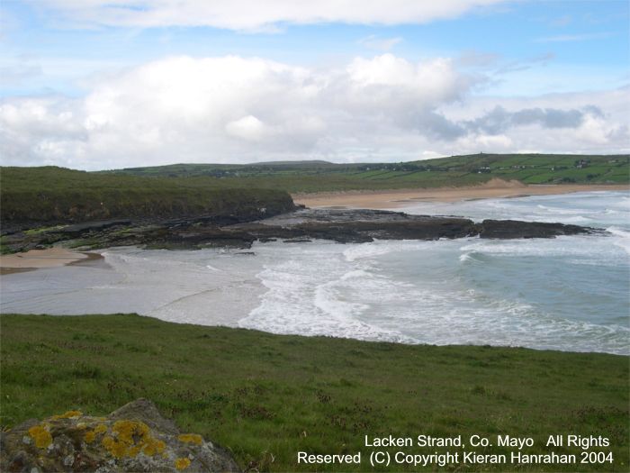
Lacken Strand, Co. Mayo
There are effectively three marks here. The first is the beach itself, (in the distance in the photograph above) rarely crowded in the summer despite the mushrooming holiday homes in the area and subject to exceptionally large surfs. There is a strong cross currents but it is popular with the surfing community. A spine of rocks cuts off a small cove to the east. Most people fish in front of the river outlet to target the flatfish, predominantly Flounder with the odd Plaice, with Thornback Rays taken on calm nights during the summer. The odd Dogfish and even rarer Bass is also taken, the latter only with a decent surf running and ideally at dawn or dusk. Mackerel is the usual bait for the Bass, with lugworm and cocktails used for the Flatfish. There are some small Turbot taken on this beach, invariably to mackerel strip but the Dogfish usually get there first! Given its proximity to Killala Bay (around the headland) I do believe that Tope should be possible from the shore and from the eastern cove walls. The second mark is that set of rocks running out to sea from the point at which the eastern road terminates in a green grassy carpark. This is good Bass country in the right conditions but the rocks are very treacherous between the seaweed and the vertical chasms and potholes in the rock itself - not a place for wading. In a strong surf the currents and backwash can be really spectacular, putting paid to all possibility of wading. A good spot to try the SWFF (salt water fly fishing) but a windy one too. On calm days Mullet will cruise in from around the Pier on the far western side of the bay. The odd one falls to lugworm. The final set of marks is effectively underneath the near cliff in the photograph. The cliffs are in fact made up of flat rocks and you can walk the entire distance out to the headland's end if you wish. A lovely spot mind but very exposed! The signifcant beneit of the flat rocks is that you have access to deep water at any stage of the tide, indeed if you are targetting Bass (and to a lesser extent Turbot) you can "walk" alongside the third breaker in from the point. A sandeel on a float is a good tactic and will work, although I have had Flounder and even Wrasse take them too! Doubtless legering close in on the weedy fringe will attract the Congers, possibly some Bull Huss and maybe even Pollack. The mark fishes well in the winter, at low water, for Codling but it can get inundated with "ribble" - small 1 kilo Coalfish. Whiting show up on occasion. Right out at the point there is some ferocious currents and these hold the best Pollack in the summer, but it needs to be a very calm day indeed...
Probabilities: Mackerel, Pollack, Mullet (summer); Coalfish, Flounder (resident, winter) Possibilities: Dabs, Bass, Lesser Weeverfish (care needed); Codling (winter). Rare Exceptions: Bull Huss, Conger Eel, Dogfish, Turbot, Whiting, Thonback Ray, Tope. |